
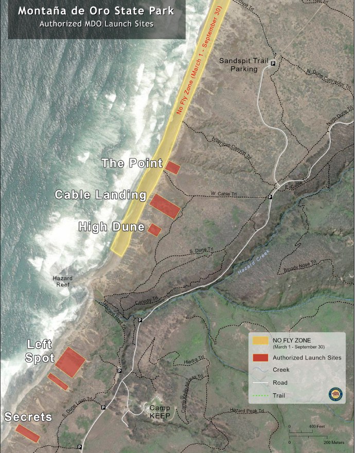
Please note: we have a NO FLY zone from March 1 - Sept 30, due to Plover Season. It is shown on the map (below). In addition to the NO FLY zone, we are restricted to the Secrets and Left Spot launch/LZ sites, please read the launch descriptions below.
MDO requires new members to check-in with a site monitor & all members must sign in at the trailhead or on-line, per our use permit with the State Park. Please help us keep this precious site open.
Site Description
This site is located in Montana de Oro State Park SW of the City of Los Osos.
From Highway 101, take Los Osos Valley Road through the city of Los Osos. Los Osos Valley Road will change to Pecho Valley Road when it turns parallel to the coast.
The main flying site launch is off the scenic bluffs. Note however, this site REQUIRES A CHECK-OUT by a SLOSA member. Our use permit requires us to educate our members and keep them appraised of the dynamic changes to restricted areas of the beach used by Snowy Plovers for nesting areas. Landing in the protected areas is prohibited.
A check out from a knowledgeable local pilot or instructor is required by our conditional use permit.
Mandatory Site Protocol
- Must be members of SLOSA and USHGA, no exceptions.
- MUST SIGN-IN at sign-in box (beginning of cable landing trail), or via the club's on-line sign in form prior to flying. Provide date, time, Name and Wing colors on-sign-in log.
- Must use only designate areas for launching and landing within the Park boundaries. This information to be provided during the Site Check-out.
- Pilots should have a P-2 or H-2 to fly the site. All pilots new to the site must be checked out by local SLOSA member prior to flying the site.
- All pilots must wear a helmet and reserve parachute.
- All flights must be in accordance with FAR Part 103.
- No dangerous maneuvers.
- No commercial (for profit $) training allowed.
- No advertising/exposure of MDO as an authorized flying site.
Site Hazards
Significant rotor can be encountered behind ridges and at gully transitions. Wind can and often does blow out in the afternoon which can blow back pilots into rotor zones behind ridges. Stay on the paths and if top landing, land in open landing locations as scrub chaparral is full of poison oak and sticky plants to snare your wing and lines.
The flat ridge south of the Point Launch is known to cause rotor, pilots should not fly behind the ridge in this section.
Pilots should not launch Secrets for Left spots in winds over 15, and recommended only for pilots with experience at the site and advanced skills.
Pilots should always remain ready to have an appropriate beach landing area planned. Winter is the least likely season for this to occur, thus the best season for flying.
Pilots should avoid flying behind the ridge, except when landing at the point, and recommend only go behind the ridge directly at the point.
Pilots should monitor winds speeds, presence of white caps and growing caps indicate pilots may need to consider landing soon.
Speed wings are allowed at this site. All mini/speed wings are to be flown with safety. No swooping near spectators nor acrobatic flying is to be engaged in.
Any violation of the rules will result in restriction from the site.
Thermal blocking, or sheer block, occurs under certain conditions, that are not completely known or understood, though several possible theories exist. Locals observe this to happen most often when air temps are at or over 63 degrees, but it can happen at various temps. Thought to be a type of sheer that blocks the ocean air from reaching the ridge. If block has set in pilots may notice white caps on the water, but feel no wind at launch. If already in the air, pilots can experience extreme lift at the front of the block sheer, generally the ocean side of the sheer, assuming the sheer runs parallel to the beach. And can experience extreme sink, and turbulence at the back side of the block sheer, or inland side. It is suggested to stay over the beach, and head towards lower dunes to loose altitude if you experience higher than normal lifting or sinking conditions. Note that the wind may be blowing onshore, or offshore when you land, and can be variable. This is an extremely complex topic, that REQUIRES site introduction with an experienced local to be explained. This is a very general description of these conditions, and should not be considered a full and proper introduction to the site, or blocking conditions.
Launch Sites
Wind speed direction and considerations apply to all launch sites. All launch sites are considered launch AND LZ.
The Point- (CLOSED during plover season, March 1st - Sept 30th) This is currently considered the main launch and landing during NON plover season. There are trails directly below this launch from the beach, back up to launch, in case pilots sink out to the beach below. Otherwise, launch and landing occur at the same spot on top of the ridge. This is the recommended launch and LZ for all pilots, and the most common meeting spot for site intros.
High Dune- (CLOSED during plover season, March 1st - Sept 30th). This site is most often used when winds are too light to maintain or gain altitude from the Point, or at the beginning of the flying day before winds have picked up. In moderate to high winds The Point is recommended over the High Dune.
Cable Landing- (CLOSED during plover season, March 1st - Sept 30th) This is an approved launch site, but seldom used currently due to erosion. Recommended only for pilots with extensive prior experience at this location, and offers no advantage over the other launches, other than to alleviate rare but possible congestion at the Point launch.
Left Spot/Secret Spot - These launches are considered intermediate to advanced launches, and require thorough briefing by experienced locals to identify landing hazards in case of sinking to beach below (tide pools and rock formations). As well as power lines and tree/brush hazards behind launch ridge line. These are the ONLY launches during most Plover seasons (March 1st - Sept 30th).
Best Flying Conditions
WSW to NW, 10-18 mph when temperatures generally are cool (58). At higher temperatures the site tends to thermal block. Best flying is in spring and fall. Occasional a convergence can form in front of ridge allowing for higher flights and flying out over the water. But be aware that with high on shore winds coupled with a thermal block formed off shore, the convergent air along the ridge in front block can become extremely turbulent.
Site Specifications
updated 2/18/2025
Wing Type Uses: PG/HG/Mini-Wing
Minimum Required Rating: P3/H3/M2
P2/H2 with Instructor Supervision
Wing Strength (MPH)
PG:
Minimum: 5
Ideal: 10
Maximum: 15
Gust: 10
HG:
Minimum: 5
Ideal: 15
Maximum: 25
Gust: 10
Mini-wing:
Minimum: 10
Ideal: 15
Maximum: 25
Gust: 10
Wind Direction (Degrees)
Ideal: 280 - 310
OK: 270 - 320
Min Required Glide Ratio: N/A
Latitude: 35.292266
Longitude: -120.87928
Also Required:
USHPA Membership
SLOSA Membership
SLOSA Check-in by site monitor & sign in at trailhead or On-line.